
Underground Utility Mapping


|
|
Underground Utility SurveyPipe/Cable Locator (PCL)Pipe and Cable Locator is an Electromagnetic device which has been used to locate buried pipes and cables for long time. They can be used to trace and identify an energized metallic target line.
After completion of the sweep and identification of each utility, the spatial positions of each painted mark will be positioned by surveyor to establish the survey control. The information gained will be tabulated by position and mark. Pipe Cable Locator (PCL) • Trace the utility alignments (metallic utilities) • Locate any pipe collapse • Measure the depth of utilities up to 4.5m Ground Penetrating Radar (GPR)Ground Penetrating Radar is a geophysical technique to imagine the subsurface by using radar pulses. GPR is a non-invasive method which applies electromagnetic radiation (UHF/VHF frequencies) to detect electrical discontinuities in the shallow subsurface(<50m). Generally, it achieves the results by generation, transmission, propagation, reflections and reception of discrete pulses of high frequency electromagnetic energy. It can provide accurate estimations of subsurface objects. GPR can be used in different aspects, for examples archaeology, civil engineering, military and utility detections.
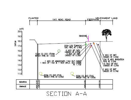
Ground Penetrating Radar (GPR) • Trace the utility alignments (metallic/non-metallic materials) • Locate any pipe collapse • Measure the depth of utilities • Locate water leakage • Detect tree roots • Detect cracks on roads, concretes or walls • Distinguish the underground features Comprehensive Utility Mapping Drawing
|